The Data Science Lab @ Maritime domain
News
- (2026.06.24) The Data Science Lab participates as beneficiary in the DIGI-FISH “Digital and Green Integration for Intelligent, Sustainable Mediterranean Fisheries & Aquaculture” EU Horizon project (GA: 101296112) that officially started on June 1st, and held its kickoff meeting today; see the project’s CORDIS page for more information about the objectives and the consortium.
- (2026.06.04) Petros Mandalis successfully defended his PhD thesis titled “Data Mining in Big Mobility Data” in front of the examination committee. Petros’ main research activity focused on vessel traffic flow forecasting; see "Research Highlights" section below for details. Congratulations to Petros and his advisor, Prof. Nikos Pelekis !!
- (2025.05.26) The Data Science Lab participates in the inaugural edition of the IEEE Maritime Symposium (MARIS) with two papers related to AIS-based data analytics, in particular on vessel location/route forecasting (see "Research Highlights" section below for details); both papers are recent results of our work under the MobiSpaces EU Horizon Europe funded project.
- (2024.05.10) The Data Science Lab participates in this year's MDM Conference with a research paper presenting our first Federated Learning- based solution on the maritime data analytics domain (see Research Highlights > Federated … section below); this is a result of our joint work with Kpler/MarineTraffic under the MobiSpaces EU Horizon Europe funded project.
- (2024.03.25) The Data Science Lab participates in this year's EDBT Conference with two maritime-related papers on Maritime Route and Event Forecasting, in the industrial and the demo track, respectively, as a result of our joint work with Kpler/MarineTraffic under the VesselAI EU Horizon 2020 funded project.
- (2023.11.14) The Data Science Lab participates in this year's ACM SIGSPATIAL Conference with two maritime-related papers, on Vessel Collision Risk Assessment and Forecasting (industrial track paper - joint work with SINTEF Ocean) and Fleet Safety Awareness over Streaming Vessel Trajectories (demo paper), respectively.
- (2023.10.09) Our Piraeus AIS dataset for Large-scale Maritime Data Analytics appears top-1 in the Google dataset search results when using the “AIS” keyword !!
- (2023.07.10) Eva Chondrodima presented our work on Maritime Analytics and Forecasting at the Maritime Informatics & Robotics Summer School, held in Syros, Greece. [more]
Research Highlights:
The Automatic Identification System (AIS) has prompted several maritime analytics tasks over vessel trajectories, including route forecasting, traffic flow forecasting, collision risk assessment (and forecasting), as well as discovering (and predicting) co-movement patterns at sea. We are consistently working on these topics, providing state-of-the-art methods and tools. In detail:
Vessel Location / Route Forecasting (VLF/VRF)
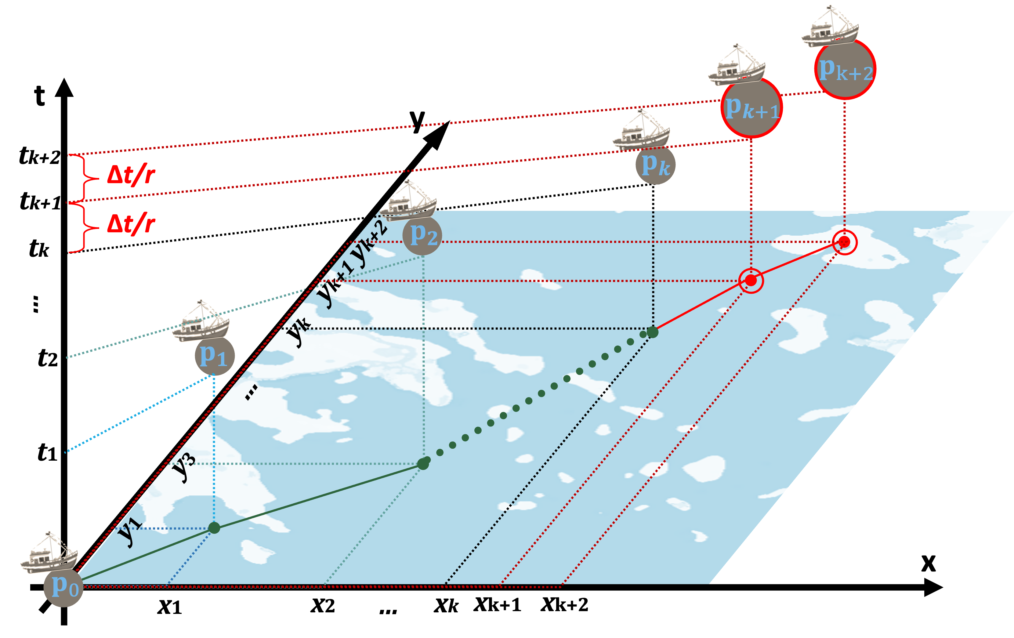
Accurate VLF/VRF, in other words, the prediction of the anticipated locations of a moving object taking into account its own or the population’s motion history is a vital part of the maritime transport systems. In our work, we propose a new VRF framework, which consists of five stages: first, historical data are fed into the framework and pass through cleansing operations. Then the spatiotemporal-aware preprocessing mechanism (including trajectory segmentation and position differences calculation) and the data augmentation method are applied. After preprocessing, the training and prediction phases follow. Finally, the predictions are transformed into the original data representation form. LSTM-based version: [GitHub #1], [AI on Demand]; XGBoost-based version: [GitHub #2]
Selected publications:
- Theodoropoulos, G.S., et al. (2025). FLP-XR: Future Location Prediction on Extreme Scale Maritime Data in Real-time. In Proceedings of the 1st IEEE Symposium on Maritime Informatics & Robotics (MARIS). [DOI] [arXiv] [slides]
- Grigoropoulos G., et al. (2024) A Scalable System for Maritime Route and Event Forecasting (Industrial Paper). In Proceedings of EDBT/ICDT 2024 Joint Conference, Paestum, Italy, pp. 762–769. [DOI]
- Grigoropoulos G., et al. (2024) GMSA: A Digital Twin Application for Maritime Route and Event Forecasting (Demo Paper). In Proceedings of EDBT/ICDT 2024 Joint Conference, Paestum, Italy, pp. 798–801. [DOI]
- Chondrodima E., et al. (2023) An Efficient LSTM Neural Network-Based Framework for Vessel Location Forecasting. IEEE Transactions on Intelligent Transportation Systems. [DOI]
- Chondrodima E., et al. (2022) Machine Learning Models for Vessel Route Forecasting: An Experimental Comparison. Proc. 23rd IEEE Int. Conf. MDM. [DOI]
Federated Vessel Location / Route Forecasting (FedNautilus)
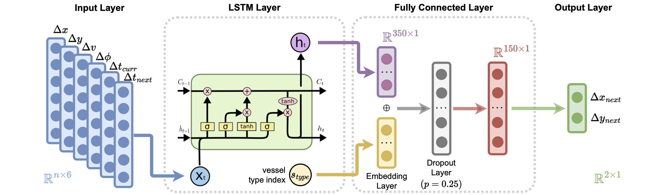
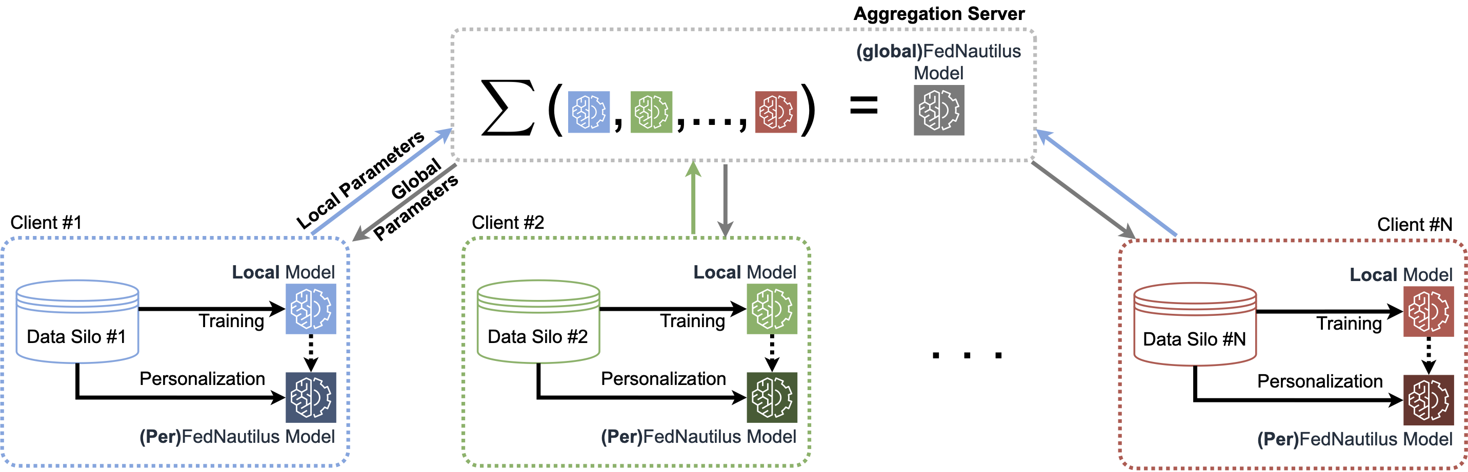

Indeed, the complexity and dynamic nature of maritime traffic make accurate VLF/VRF challenging. Nevertheless, privacy concerns usually result in fragmented training data, isolated in “data silos” across enterprises and/or countries, thus affecting the quality of learning models. In our work, we propose an efficient VLF solution based on LSTM neural networks, in two variants, namely Nautilus and FedNautilus for the centralized and the federated learning approach, respectively. We also demonstrate the superiority of the centralized approach with respect to current state of the art and discuss the advantages and disadvantages of the federated against the centralized approach. In the same line of research, we have also developed an end-to-end framework that monitors the activity of AIS-enabled vessels and utilises FedNautilus to visualise their anticipated future location in real-time, as well as providing additional Visual Analytics (VA)-oriented features. [GitHub #1] [GitHub #2] [video #1] [video #2]
Selected publications:
- Tritsarolis, A., et al. (2025). Nautilus in Motion: A Demo on Vessel Location Forecasting over Live Maritime AIS Streams. In Proceedings of the 1st IEEE Symposium on Maritime Informatics & Robotics (MARIS). [DOI] [slides]
- Tritsarolis A., et al. (2024) On Vessel Location Forecasting and the Effect of Federated Learning. In Proceedings of the 25th IEEE Conference on Mobile Data Management (MDM). [DOI] [arXiv] [slides]
Vessel Traffic Flow Forecasting (VTFF)
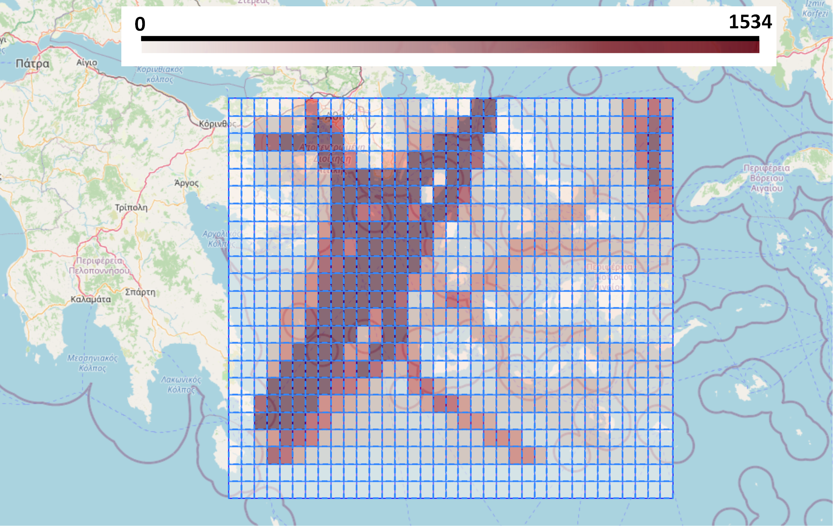
Most promising VTFF methods mostly use grid-based representation analysis, and approach the VTFF problem from two different perspectives: a) directly - by predicting the future traffic based on sequence analysis of historical traffic flow, and b) indirectly - by estimating the future traffic based on future vessel locations produced by vessel route forecasting algorithms. In our work, we examine both the above strategies and a new unified approach, which takes advantage of both the indirect and direct paradigms by utilizing the results of the indirect paradigm and feeding them into a model that approaches the VTFF problem directly.
Selected publications:
- Mandalis P., et al. (2024) A Transformer-based Method for Vessel Traffic Flow Forecasting. Geoinformatica. [DOI]
- Mandalis P., et al. (2023) Towards a Unified Vessel Traffic Flow Forecasting Framework. Proc. IEEE Int. Workshop BMDA. [DOI]
- Mandalis P., et al. (2022) Machine Learning Models for Vessel Traffic Flow Forecasting: An Experimental Comparison. Proc. 3rd IEEE Int. Workshop MBDW. [DOI]
Vessel Collision Risk Assessment & Forecasting (VCRA/F)
Accurate VCRA/F is crucial for maritime safety due to volatile traffic and weather conditions. Using complex models introduces a trade-off between quality and responsiveness. In our work, we propose a deep learning-based solution for VCRA/F, predicting collision risk probability through trajectory prediction. In the same line of research, we have also developed VesselVision, a map visualisation tool that monitors the activity of AIS-enabled vessels and utilises VCRA to visualise their current collision risk probability in real-time, as well as providing additional Visual Analytics (VA)-oriented features. [video] [[GitHub #1] [GitHub #2] [AI4EU]
Selected publications:
- Tritsarolis A., et al. (2023) Collision Risk Assessment and Forecasting on Maritime Data (Industrial Paper). In proceedings of the 31st ACM International Conference on Advances in Geographic Information Systems (SIGSPATIAL). [DOI] [slides]
- Tritsarolis A., et al. (2023) VesselVision: Fleet Safety Awareness over Streaming Vessel Trajectories (Demo Paper). In proceedings of the 31st ACM International Conference on Advances in Geographic Information Systems (SIGSPATIAL). [DOI] link
Discovering / Predicting Co-movement Patterns at Sea
The advent of GPS technologies has increased the need for efficient processing and analysis of location data-streams. EvolvingClusters, a graph-based algorithm, identifies diverse collective movement behaviors like flocks and convoys based on concurrent activities across time and space. We have evaluated EvolvingClusters using real-world datasets, demonstrating its efficiency and potential as a tool for discovering and profiling the evolution of moving objects in real-time, or in the (short-term) future via trajectory prediction. In addition, in order to visualize these patterns, we have developed MaSEC, a Visual Analytics solution for monitoring moving and stationary co-movement patterns. [slides] [video] [GitHub #1] [GitHub #2]
Selected publications:
- Tritsarolis A., et al. (2022) Predicting Co-movement patterns in mobility data. Geoinformatica. [DOI]
- Tritsarolis A., et al. (2021) MaSEC: Discovering Anchorages and Co-movement Patterns on Streaming Vessel Trajectories. Proc. 17th ACM Int. Symp. SSTD [DOI] [link]
- Tritsarolis A., et al. (2021) Online discovery of co-movement patterns in mobility data. International Journal of Geographical Information Science. [DOI]
Datasets
The Piraeus AIS Dataset for Large-scale Maritime Data Analytics
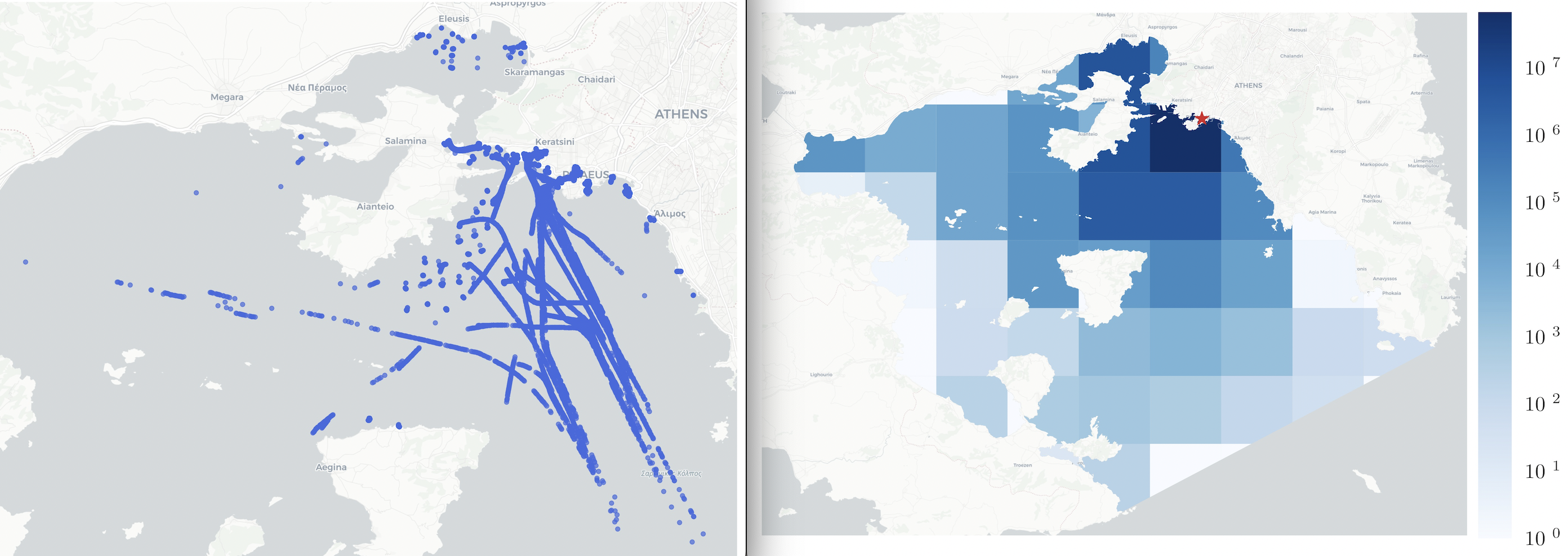
In the era of Big Data and streaming technology, there is an enormous flow of heterogeneous data, particularly in the IoT and transportation domains. We focus on maritime, presenting an AIS dataset with vessel position info from various types, encompassing spatially and temporally correlated data, even weather. Covering over 2.5 years (2017–2019), it offers anonymized vessel positions within the Port of Piraeus and Saronic Gulf, Greece, comprising a total of 244 million records (approx. 10K records per hour), which makes it ideal for large-scale mobility analytics. [slides] [Zenodo] [AI4EU]
Selected publications:
- Tritsarolis A., et al. (2022) The Piraeus AIS dataset for large-scale maritime data analytics. Data in Brief, 40, 107782. [DOI]
The Team
Prof. Yannis Theodoridis, Prof. Nikos Pelekis, Eva Chondrodima (PhD), Yannis Kontoulis (MSc), Petros Mandalis (MSc), Andreas Patakis (MSc), George S. Theodoropoulos (MSc), Andreas Tritsarolis (MSc), Antonis Tziorvas (MSc). In addition, there are many alumni and research interns who have worked with us in this project. We truly appreciate their contribution.
Funding
This research was partially funded by the following EU grants (in reverse chronological order): MobiSpaces (EU Horizon Europe Research grant, 2022-25), VesselAI (EU Horizon 2020 Research grant, 2021-23), MASTER (EU Horizon 2020 Marie Sklodowska-Curie grant, 2018-23), and datACRON (EU Horizon 2020 Research grant, 2016-18).
| |
|
| |
|